
PAGASA Releases Latest Weather Update for Thursday (October 22, 2026)
PAGASA – The state weather bureau reported that Super Typhoon Rosal has slightly weakened, while signal no. 2 was still up in some areas.
On Thursday (October 22, 2026), the Philippine Atmospheric, Geophysical, and Astronomical Services Administration released the latest weather update in the country. Super Typhoon Rosal still affect the country’s weather condition.
PAGASA reported that Rosal was last spotted 495 kilometers (km) east of Basco, Batanes with maximum sustained wind speeds of 195 kilometers per hour and gustiness of up to 240 kph.
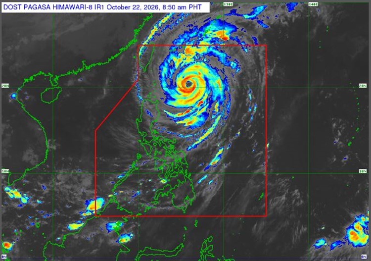
“Rosal will continue to gradually weaken and may be downgraded into a typhoon within the day,” PAGASA said.
The super typhoon is set to pass Extreme Northern Luzon between Thursday afternoon and Friday morning (October 23) before leaving the Philippine Area of Responsibility on Saturday (October 24).
Meanwhile, signal no. 2 is still up in Batanes and parts of Babuyan Islands. Signal no. 1 is still up in the following areas:

- The rest of Babuyan Islands
- The eastern portion of Isabela (Maconacon, Divilacan, Palanan, Santa Maria, Cabagan, Delfin Albano, Santo Tomas, Tumauini, San Pablo, Ilagan City, San Mariano, Dinapigue)
Rosal is expected to gradually weaken and may be downgraded to a typhoon. After a few days, it is set to weaken into a severe tropical storm.
The coastal water condition over eastern sections of Central Luzon, Southern Luzon, and the Visayas will be moderate to rough. Slight to moderate seas is expected over the remaining parts of the country, according to PAGASA.
This is a developing report, just visit this website regularly or refresh the page for further updates.
READ ALSO: PAGASA: Super Typhoon Champi to Enter PAR on Tuesday (October 20, 2026)